NEWBURYPORT – As walkers and joggers make their way along the Clipper City Rail Trail, the walkway divides into two paths just north of Washington Street. Both paths are wide, but are divided by a long iron beam that if you are blind or have low vision could be a hazard.
But as of this week, the blind and low vision or just those not paying attention to where they are walking have a guide that alerts them to the split in the path as it crosses above Merrimac Street. The beloved Clipper City Rail Trail can now talk to people on their cell phones.
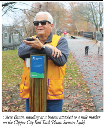
Funded by the Newburyport Lions Club, the first 11 beacons along the 1.6-mile trail that are attached to wooden posts will talk to you on your phone – if the free app is downloaded to your phone. They give directions, warn of hazards such as street crossings, locate benches if you need a rest or point out interesting sculptures and other features like play equipment for children.
The beacons, which cost $22,000 for a total of 17, will be unveiled officially at 11 a.m. on Monday, Dec. 8, on the trail along the waterfront behind Starboard Galley. The remaining six beacons are scheduled for installation in the spring.
“I am very excited” Barans said, watching his dream come alive.
It is a dream brought to life by Newburyport Lions Club president Barbara Round, who is sighted, and spearheaded by Steve Baran, a club member who has been blind from birth. The 30-member Lions Club, which has raised more than $600,000 for research on the blind, is working with an Israeli technology company, RightHear, to produce and install the beacons.
The messages being developed now are largely directional, a first for most rail trails to be inclusive of low-vision users. But the technology may prove to be equally valuable as an electronic concierge or tour guide for visitors and newcomers to Newburyport as well as solve the challenge of adding more directional signage.
The beacon at the Divided Bridge greets trail users in a female voice with these messages:
Divided Bridge
Face Northeast toward the Waterfront. Face Forward, stay on the right side of the trail to the bridge. The bridge has a large divider down the middle of it breaking the trail into two sides. Continue walking the trail to the waterfront and downtown.
To the East, there is a bench (dedicated to the dog, Izzy, a “girl’s best friend.”)
The bench on the edge of the trail just before the bridge on the Parker Street Train Station side
To the Southwest, MBTA Purple Train at Parker Street
Face Forward stay on the right side of the trail to the bridge. The bridge has a large divider down the middle of it breaking the trail into 2 sides. Continue walking the trail to the MBTA Purple Train at Parker Street
To the West: There is an exit to Strong Street which takes you to Water Street. There are no beacons to assist when you leave the rail trail.
The beacons speak in 36 languages, which helps non-English-speaking residents and visitors.
The directional messages, which are given in feet or steps, are helpful to those with low vision or, as one sighted walker said last week, it will be helpful for those who are directionally challenged.
Rounds, who is a strong advocate for inclusivity, said, “If you join the rail trail at Low Street, how do you know which way is the waterfront?”
The beacon also gives different messages that describe the trail’s features that would be what a sighted person would see. The message says: There is a bench about 50 feet after entering the rail trail. After the bench is a garden with a pathway There are sculptures along the trail. The first sculpture, “Sparrows” by Dale Rogers (2011), shows two birds gliding side by side in vertically tilted posture.
Next, the message continues, is The Alchemical Garden and a Little Free Library. Then there is Clyde already waiting for you. “Clyde” is a horse sculpture by James Burnes (2009) made of corten weathering steel and black locust wood.
Geordie Vining, the city’s senior planner, who spearheaded the development of the rail trail, wrote: “Installing the RightHear beacons on the Rail Trail is a really positive proposal and a really interesting use of technology to make the (trail) more accessible to everyone. I like how the system seems set up to provide real-time orientation information to users, as well as information about various landmarks and facilities as well as hazards. E.g., the interpretive signs; the sculptures, gardens, and murals; the benches, tunnels, bridges, intersections, stairs, side paths, etc.”
Approved by the city’s Parks Commission, the beacons will be maintained by the club on a three-year-contract with RightHear.
The project was born out of Baran’s frustration with so-called Braille Trails, which employ guidewires to help low-vision trail users. But the equipment is expensive, frays, gets hot in the sunlight and benefits a limited number of people, Round said.
Baran read in a newsletter that the Natural Bridge State Park in Virginia was experimenting with the RightHear beacons. He and his wife, Denise Dodge, drove to Virginia in an ice storm last winter to learn more about the beacons.
The RightHear beacons met all of Baran’s objectives for the trail project. He wanted it to be easy to use, allow low-vision persons to walk safely and independently and help the most people by broadcasting from existing mile markets. The beacons are non-invasive.
Founded in 2016, RightHear has transformed more than 2,400 venues worldwide, making them accessible to people with low vision or orientation challenges.
To download the app, visit righthear.com and follow the instructions, which include an orientation session.